


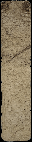
Ried Frechau-Sandgrube
The soil from Frechau is a deep-profiled pararendzina composed of loess with a typical silty texture. This deep soil has very good water-holding capacity. The fertile soil is ideally suited to Grüner Veltliner. The parent material is loose, yellowish, powdery loess of a classic character. Loess is calcareous rock dust (silt) which was blown here from the Alpine region during the vegetation-poor cold phases of the Ice Age, originating from the bare foredoms of the glaciers and river plains, and now forms a loamy-sandy, consistently calcareous and highly water-retentive soil with a balanced chemical and mineralogical composition.
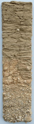
Ried Gottschelle
The Gottschelle profile shows, in its upper section, sandy-loamy loess that appears unusually layered. Between the loess and the gravel, an old soil formation with an accumulation of secondary lime can be seen. Also clearly visible is the erosional channel in which the fine material cuts into the underlying gravel. The lower part of the profile consists of low-lime gravel, which marks an ancient valley floor of the Danube and lies approximately 25–30 metres above the current river level. The gravel is predominantly composed of quartz, quartzite and crystalline rocks.
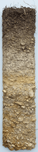
Ried Grillenparz
The profile of the Ried Grillenparz shows a rendzina. The mineral humus lies directly above the highly calcareous parent material. This soil originates from an area of the Ried that has not been drained or terraced, and shows no mixing of topsoil and subsoil material. The shallow soil has a high stone content and is therefore prone to summer drought. The parent material consists of the conglomerates and sandstones of the Hollenburg-Karlstetten Formation, which are only weakly consolidated here. The deposits of the Hollenburg-Karlstetten Formation consist largely of calcareously cemented, rounded stones and boulders, comprising carbonate rocks, namely conglomerate. Overlying this is a fine-grained, sandy sedimentary sequence, before boulders reappear in the topsoil.
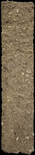
Ried Kremser Gebling
The soil at Kremser Gebling is an uncultivated raw soil that has been significantly altered by terracing work. The humus horizon is therefore still relatively poorly developed. The high loess content ensures a balanced water regime. The parent material consists of fine-grained material strongly influenced by the adjacent conglomerate formation, which is partly composed of loess. The fine material is densely intermixed with calcareous gravel and boulders. These originate from the deposits of the primeval Traisen, which, around 15 million years ago, carried rock material from the Limestone Alps into what was then the sea.
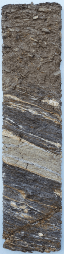
Ried Kremsleithen
The profile from Ried Kremsleithen is a ditched vine plot. The soil is dry and contains a high proportion of gravel and stones within the loamy-sandy fine-textured soil. The subsoil consists of bedrock with distinct light-coloured layers and lenses within the dark amphibolite. The mineral composition is dominated by green hornblende, alongside plagioclase and other feldspars, as well as occasional garnet, epidote and quartz. Hornblende is absent from the light-coloured layers. In terms of their original formation, the amphibolites originated from basaltic flows on the ocean floor, which were later metamorphosed during mountain-building, thereby acquiring their banded appearance.
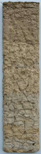
Ried Neuberg-Frauengrund
Beim Profil aus der Ried Neubergen handelt es sich um eine Pararendzina aus Löss. Die schluffige Bodenart und tiefe Gründigkeit sorgen für einen ausgeglichenen Wasserhaushalt. Der scharfe Übergang vom Mineralhumus zum Ausgangsmaterial zeigt die vormals tiefgründige Bodenbearbeitung. Vermutlich war hier früher einmal ein Acker. Den tieferen Teil des Profils, das Ausgangsmaterial für den Boden, bildet Löss. Die obere Partie zeigt auffallend viele helle, kalkige Konkretionen.
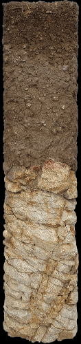
Ried Pfaffenberg
The soil at Pfaffenberg is a medium-depth rigol soil consisting of loamy sand with a significant content of coarse gravel. The humus horizon is clearly visible due to its dark colour. The soil is lime-free; only when mixed with loess is a slight lime content possible. Due to its sandy texture, the soil warms up quickly in spring, ensuring rapid budbreak in the vines. The bedrock consists of Gföhl gneiss from the Bohemian Massif, a light-coloured, acidic rock composed mainly of the minerals feldspar, quartz and mica, predominantly biotite. The fine fissuring is clearly visible through reddish-brown, iron-rich deposits. This facilitates water circulation and allows the roots to penetrate deep into the ground.
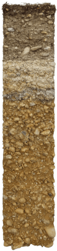
Ried Wachtberg
The soils of the Ried Wachtberg are pararendzinas derived from silicate-calcareous parent material. The very dark colour in the top few centimetres indicates a particularly high level of humus enrichment in the root mat. The high stone content and the gravelly-sandy parent material indicate that the soil has a comparatively low water-holding capacity. The mineral-humus horizon, approximately 25 cm thick, lies above a horizon of secondary limestone. The bedrock consists of sandy, well-rounded gravels from the Hollabrunn-Mistelbach Formation. These are approximately 8 million-year-old deposits from a river known as the Urdonau, which at that time flowed into the Vienna Basin considerably further north than today’s Danube.
Ried Weinzierlberg
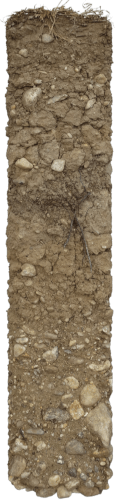
The soil on the Weinzierlberg is a calcareous pararendzina consisting of reworked loess overlying sandy gravel. Due to the high proportion of loess, silt predominates in the fine-textured soil. The underlying sandy gravel is covered by layers of varying thicknesses of silty, calcareous, wind-blown loess or fine-grained floodplain sediments. In the subsoil, there are moderately to poorly rounded, sandy gravels and stones. These trace an ancient, glacial valley floor of the Danube, which lies some 45 metres above the river’s present course. The range of components is dominated by quartz boulders, although crystalline and calcareous Alpine boulders also occur.